|
Government of Nepal Ministry of Federal Affairs and Local Development (MoFALD) Department of Local Infrastructure Development and Agricultural Roads (DoLIDAR) Community Irrigation Project (CIP) |
About the project
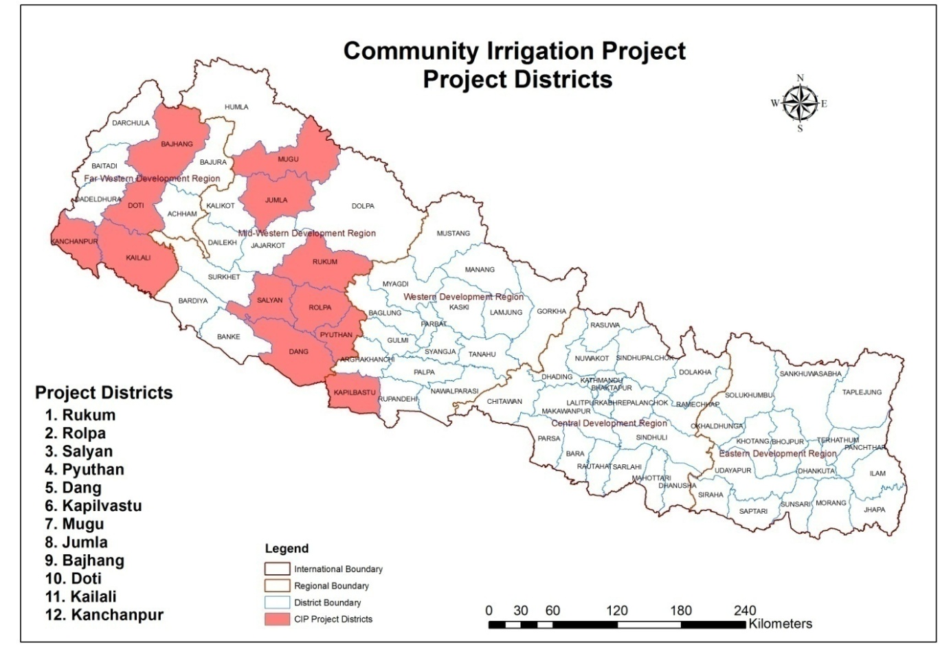
The Community Irrigation Project (CIP) will develop or improve small-scale irrigation systems in 12 districts in Nepal through a community-driven process targeted to the poor, women, and other disadvantaged groups. The participating districts were selected based on high poverty, food insecurity and irrigation potential, and include Kanchanpur, Kailali, Dang, Kapilvastu in the Terai plains, Doti, Salyan, Rukum, Rolpa, Pyuthan in the hills, and Bajhang, Jumla, Mugu in the mountains. The project is estimated to cost $36.8 million (Asian Development Bank $26.4 million, Beneficiaries $3.8 million, Government $ 6.6 million).
Irrigation Subprojects
CIP aims to develop irrigation infrastructure covering 13,000 ha of agricultural land of small surface FMIS (having command area less than 25 ha in the hills and mountains and 200 ha in the Terai) and development of 4,000 ha of STW groundwater irrigation systems with 40 ha cluster area. Subprojects will be implemented in four batches of which 1st batch consists of 50 subproject, 2nd batch of 160 subprojects, 3rd batch of 108 subprojects and 4th batch of104 subprojects. The subprojects comprises of (i) improved irrigation infrastructure, (ii) improved agriculture practice and access to microfinance, and (iii) Government capacity building.
Irrigation Infrastructure Development
The project will respond to requests of WUAs to improve or provide new small-scale irrigation infrastructure. These may include (i) the rehabilitation and extension of existing farmer-managed or new surface water irrigation systems, (ii) pond/tank systems with reticulated pipe conveyance and distribution systems, (iii) pumped (or “lift”) irrigation systems, and (iv) STWs. The project aims to improve water use efficiency and productivity within customary water withdrawal practice through improved conveyance and use of micro-irrigation application and water conservation technologies.
Agricultural Development
Appropriate agricultural extension activities will be conducted in each subproject area based on the needs of the WUA and the potential for crop diversification towards higher value crops. Extension activities will be managed and delivered in subproject areas by the VBFT and Irrigation Agronomist/PMIS, with engagement of Department of Agriculture staff as resource persons and experts for training events. Women and disadvantaged groups will be formed to address their specific agricultural needs. Training of trainers programs will be provided in such topics as input supply, crop variety and seed selection, soil preparation and fertility management, and on-farm water management. Other specific training programs may be conducted in crop husbandry (including pest and disease management), seed production and multiplication, and marketing.
Socio-Economic Development
Support will be provided to improve farmers' access to inputs and markets, and enhanced production skills, in order to help farmers achieve their targets in cropping intensity and yields. The project will help facilitate access to micro-credit for agricultural inputs, irrigation equipment, and irrigation infrastructure operation and maintenance by enabling local micro-finance organizations to offer savings and credit services to the project subproject areas. Supplementary capacity development will be targeted toward disadvantaged groups to enable their effective participation and linkages to third party programs relevant for their needs.
Microfinance
Under the Community Irrigation Project the microfinance training component aims to faciliate access to micro-credit for agricultural inputs, irrigation equipment, and irrigation infrastructure operation and maintenance by enabling local micro-finance organizations to offer savings and credit services to the project subproject areas. The project component includes: 1)Identification of new MFIs (Microfinance Institutions) in the project districts, 2) Capacity building and strengthening of prospective MFIs, 3) Technical assistance to MFIs 4) Conduct training, workshop, study visits etc. for MFIs.
CIP Project Map
Google based maps are available for all the projects. Click enabled maps are provided for batch I, II , III and IV. The maps shows the Intake, Command Area, Main Canals and Branch canals along the user updated photographs, notes etc. In order to view the detailed map, Google Earth should be installed in the computer.
Capacity Building
The Community Irrigation Project capacity development plan is in support of the action plan and will build capacity of i) local bodies to transparently target project benefits to disadvantaged groups according to sub project selection criteria; ii) water user associations (WUAs) and individual irrigation farmers to sustainably maintain their irrigation systems and adopt improved irrigated agronomy practices; and iii) district engineers and agricultural productivity. In the process, the capacity of the executing agency will be built to participate in small irrigation development at the national level and to implement time bound decentralized public development programs in small irrigation.